购买
下载掌阅APP,畅读海量书库
立即打开
畅读海量书库
扫码下载掌阅APP

5.2 Ground surface control survey

5.2.1 The coordinate and the elevation reference points shall be determined according to status quo of the existing control network in the project site,the coordinate and elevation systems,the network layout method,and the network hierarchy and the accuracy.When a construction control network is set up,the horizontal and elevation control networks should be used together with the local control network.

5.2.2 The horizontal control network may be based on the methods such as the satellite positioning survey method or the traverse survey method.On the premise of meeting the accuracy requirements given in Table 5.2.3-1 and Table 5.2.3-2 in this code,the horizontal control network may also be based on other network layout methods.

5.2.3 The horizontal control network survey technology shall comply with the following requirements:

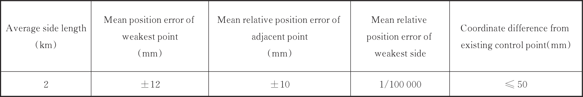
1 The technical requirements for horizontal control network survey based on satellite positioning are shown in Table 5.2.3-1.

Table 5.2.3-1 Technical requirements for horizontal control network survey based on satellite positioning

2 The technical requirements for traverse control network survey are shown in Table 5.2.3-2.

Table 5.2.3-2 Technical requirements for traverse control network survey

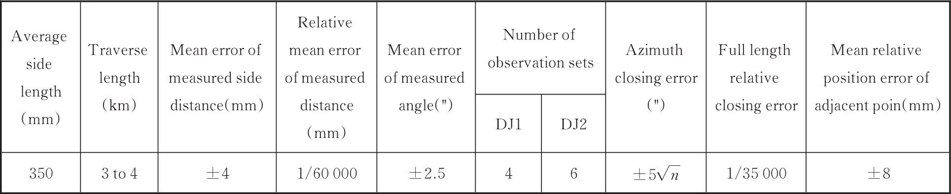
Note: n is the single-way number of observation stations.

5.2.4 The elevation control network may be laid out once for all using the leveling survey method,or it may be laid out using the triangular elevation survey method of the same accuracy.The technical requirements for the elevation control network(leveling)survey are shown in Table 5.2.4.

Table 5.2.4 Technical requirements for elevation control network(leveling)survey

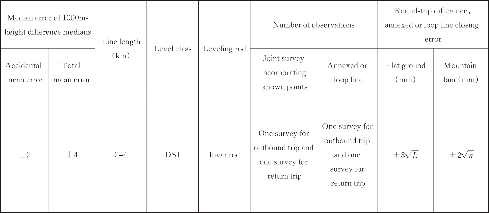
Note: L is the length of the return survey section or annexed or loop line(km),and n is the number of survey stations in the single trip.

5.2.5 A unified construction control survey system shall be established for the storage cavern construction section.The horizontal control coordinate system shall meet the requirements that the projection length in the entire storage cavern survey area shall not be greater than 25mm/km,and each tunnel portal shall be provided with at least three horizontal control points and two elevation control points. I43T1sCc+WqrWM39UzlM2tJShibDrHcKRTQJ6lVtbOqW/txunn7cO+iojzGd5/gn


5.3 Underground control survey

5.3.1 The underground control survey shall comply with the following requirements:

1 The angular mean error of the underground traverse control survey shall be determined in accordance with Table 5.3.1-1,depending on the length of the control line.

Table 5.3.1-1 Angular mean errors of underground traverse control survey

Note: L is the maximum length of the control line.

2 The 1000m-elevation difference total mean error of the underground elevation control survey shall be determined in accordance with Table 5.3.1-2,depending on the control line.

Table 5.3.1-2 1000m-elevation difference total mean error of underground elevation control survey

Note: L is the maximum length of the control line.

5.3.2 The establishing of the underground horizontal control network shall comply with the following requirements:

1 The underground horizontal control network should be of traverses,and long-side traverses or narrow and long multi-loop traverses shall be set up along the centerline or both sides of the storage cavern,with the application point of the portal(inserting point)as the starting point.

2 The traverses should have equal side lengths.In the straight sections,the side length of the traverses should not be shorter than 150m;in curved sections,the side length of the traverses should not be shorter than 50m.The clear distance between the traverse side and the underground facilities should not be shorter than 0.5m.If the side length of the traverses in the straight sections is shorter than 150m or that in the curved sections are is shorter than 50m,the number of the survey cycles or the accuracy of the instruments shall be increased.

3 When the cavern is excavated to 2 times to 3 times the designed traverse side length,one traverse extension survey shall be performed.

5.3.3 The underground elevation control survey shall comply with the following requirements:

1 The leveling points should be set up at intervals of 200m;

2 The leveling points may be based on the traverse points or may be laid independently;

3 The underground elevation control survey should be based on the leveling survey method.It may also be based on the triangular elevation survey method.

5.3.4 The underground construction survey shall comply with the following requirements:

1 The cavern construction centerline should be set up using the polar coordinate method according to the underground control points.When the excavation distance extends to one or two times the traverse side length,new centerline points should be set according to the extended traverse points.

2 When the centerline method is used,the interval of the centerline points should not be shorter than 100m. I43T1sCc+WqrWM39UzlM2tJShibDrHcKRTQJ6lVtbOqW/txunn7cO+iojzGd5/gn


5.4 Cross-section survey

5.4.1 After an excavation cross-section is formed,cross-section survey shall be made.

5.4.2 The interval of the cross-section survey shall comply with the requirements in Table 5.4.2.

Table 5.4.2 Invertal of cross-section survey I43T1sCc+WqrWM39UzlM2tJShibDrHcKRTQJ6lVtbOqW/txunn7cO+iojzGd5/gn

点击中间区域
呼出菜单
上一章
目录
下一章
×