
下载掌阅APP,畅读海量书库
立即打开


 Descent of Lithosphere beneath New Hebrides, Tonga-Fiji and New Zealand: Evidence for Detached Slabs
M. Barazangi et al .
Editor’s Note
At subduction zones, one tectonic plate plunges down beneath another into the Earth’s mantle. The descent of the lower plate can trigger deep earthquakes. Bryan Isacks of Cornell University, together with Peter Molnar, suggested that a “gap” in seismic activity below a subduction zone might indicate that part of the descending slab had broken off from the rest. Here Isacks and coworkers present evidence that this has happened in the subduction zone containing the New Hebrides islands in the southwest Pacific, and most probably in that of New Zealand. They also suggest that the New Zealand and Tonga-Fiji slab cannot penetrate below 700 km, owing to a “discontinuity” in the mantle that subsequently became a major focus of geophysical studies. 中文

Study of seismic wave propagation in the mantle beneath the New Hebrides island arc shows that the remarkable gap in seismic activity between deep and intermediate depth earthquakes at the northern part of the arc corresponds to a gap in the lithospheric slab descending beneath the arc: the deep earthquakes mark a detached piece of lithosphere. Although observations for New Zealand deep earthquakes are ambiguous, other evidence suggests the detachment of lithosphere beneath New Zealand. 中文

ONE of the outstanding features of the distribution of earthquakes in the upper mantle is the existence of gaps in seismic activity between depths of about 300 and 550 km. These gaps are prominent beneath South America, New Zealand, and the New Hebrides island arc. They are of great interest because of the implication that portions of lithosphere can break off from the descending plate and exist as isolated slabs within the mantle. 中文
Here we present evidence from study of seismic wave attenuation for the detachment of lithospheric slabs in the upper mantle beneath the New Hebrides arc. Detachment is also indicated by travel time data and reconstructions of the past movements of plates in the region. We concentrate on the study of seismic attenuation because the effects are large and easy to observe and interpret 1-3 . 中文
Isacks and Molnar 4 suggest that the gaps in seismic activity as a function of depth can be explained by two models. In the first the stress inside a continuous slab varies from down-dip extension at intermediate depths to down-dip compression at greater depths, and thus is near zero between these depths. In the second a piece of descending lithosphere breaks off, sinks into the upper mantle and leaves a gap between the piece and the plate to which it was attached. The character of seismic waves, especially shear waves, produced by deep earthquakes and recorded at stations along island arcs where large gaps in seismic activity exist provides evidence for determining which of these models is correct. Observation of attenuated, low frequency waves for the appropriate paths indicates a gap in the descending lithosphere. But if high frequency shear waves are observed, then the interpretation is ambiguous. The observations can be explained either by propagation along a continuous high Q lithospheric slab or by propagation through the upper portion of a discontinuous slab that provides a low attenuation path through the asthenosphere. The second explanation implies that for 1-3 Hz shear waves attenuation is small below depths of about 300 km. 中文
The New Hebrides island arc provides a unique opportunity to study the nature of the gap in seismic activity in the upper mantle. Seismograph stations are well distributed along the arc. The gap is well established between depths of about 300 and 600 km. The structure of the intermediate and deep seismic zones with the very steeply dipping intermediate zone and the approximately horizontal deep zone certainly suggests that the two zones may not be connected. Enough deep earthquakes have occurred since the stations were installed to provide a large sample of paths. Forty deep earthquakes in the 10 year period 1961-1970 were recorded at Noumea (NOU) and Port Vila (PVC) stations (Fig. 1). Lonorore (LNR) was established in 1968. NOU, PVC and LNR employ 1 Hz underdamped seismometers and 2 Hz overdamped galvanometers. The instruments have a relatively flat response for seismic wave frequencies between 0.5 Hz and 10 Hz and thus record very clearly the large variations of shear wave frequencies. Detailed description of the New Hebrides-New Caledonia seismic network is given by Dubois 5 . 中文
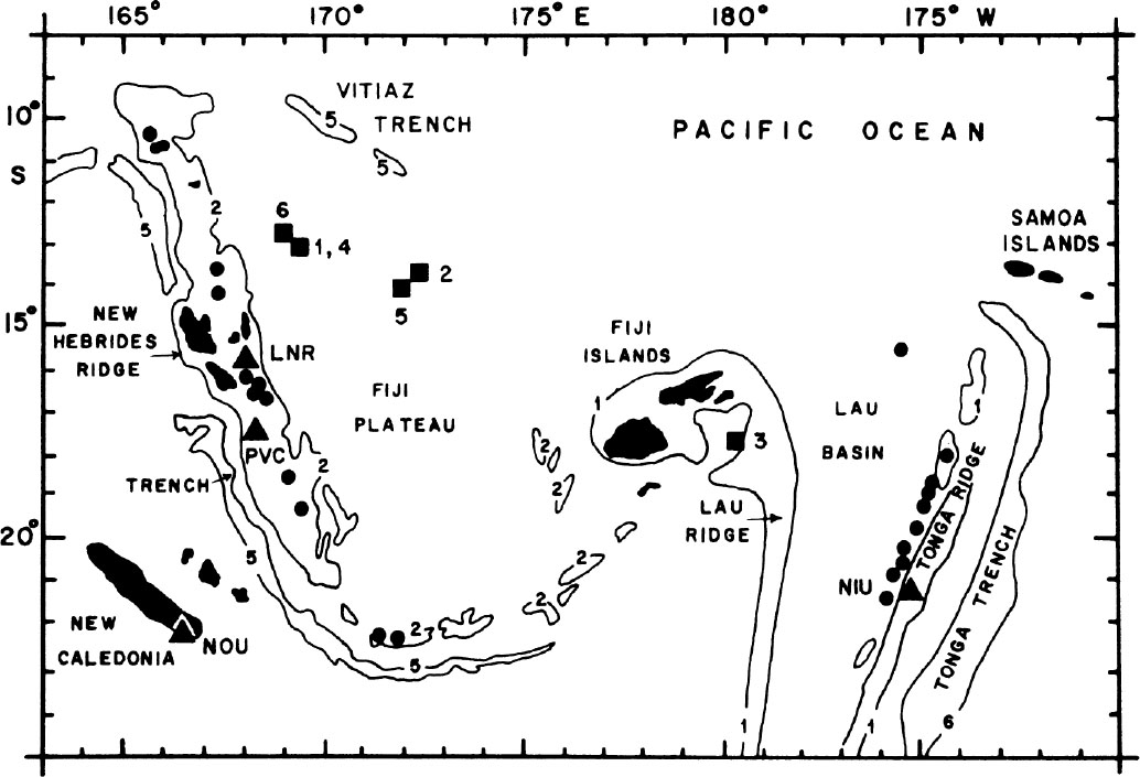
Fig. 1. Map showing the Tonga-Fiji-New Hebrides region of the southwest Pacific. ●, Historically active volcanoes; ▲, seismic stations; ■, locations of deep earthquakes used in Figs. 2 and 3. Water depths are in km.
The inclined seismic zones of South America also have remarkable gaps in seismic activity between about 350 and 550 km. A detailed study of the records produced by almost all the South American deep earthquakes that occurred during the past 10 yr at stations along the western coast of South America is currently under way, and will be reported in a separate study. 中文
Fig. 1 shows the location of the stations in New Caledonia and New Hebrides used in this study. We have examined all the records produced at these stations by the New Hebrides deep earthquakes. The most striking observation is that predominantly low frequency (about 0.5 Hz) S waves are recorded at PVC and LNR from the deep earthquakes north of 15° S. 中文
Fig. 2 shows a cross-section through the New Hebrides arc that intersects NOU, LNR and passes close to PVC. New Hebrides deep earthquakes located at the western part of the deep zone (very close to the downward projection of the intermediate depth zone) produce attenuated, low frequency S waves at PVC. The ray paths pass just beneath the dipping seismic zone. Frequencies greater than 1 Hz are absent and the amplitude of the S phase is generally less than that of P phase. As Oliver and Isacks 1 and Barazangi and Isacks 3 show, this can be explained by a transmission through an attenuating low Q zone. In contrast, S waves recorded at NIU station on the Tonga island arc from Tongan deep earthquakes have predominant frequencies of 3-4 Hz and the amplitudes of S are generally larger than those of P. 中文
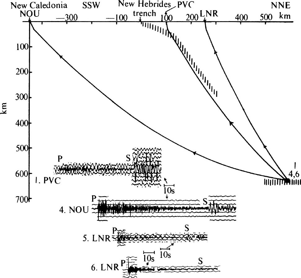
Fig. 2. Cross-section of the New Hebrides arc showing J-B ray paths to NOU, PVC and LNR stations and the corresponding records [E-W component at PVC, N-S component at NOU, and Z component at LNR] and the locations of seismic activity (vertical lines). Only low frequency S waves are recorded at the stations.
Deep earthquakes also produce low frequency shear waves at LNR, a station close to the active volcanic line of the New Hebrides arc. This is in marked contrast to the observation of high frequency S waves from Tonga deep earthquakes at stations along the active volcanic line of the Tonga arc 6 . 中文
We interpret the observation of low frequency S waves at PVC and LNR to be mainly the result of attenuation along the path. The effect of the source can be excluded since New Hebrides deep earthquakes produce seismograms at Fiji stations that are similar to those produced by the Tonga deep earthquakes (the New Hebrides and Tonga deep earthquakes are approximately equidistant from the Fiji stations). The effect of the station can be excluded since intermediate earthquakes located along the New Hebrides arc produce, without exception, high frequency (about 3-4 Hz) S waves at PVC and LNR. This is so even where the path lengths are comparable or greater than those from the deep earthquakes. Further, the Tonga deep earthquakes produce seismograms at PVC and LNR that are strikingly similar to those produced at the Fiji stations. Thus, attenuation along the path is the main cause for the observed low frequency S waves at PVC and LNR. 中文
The attenuation is chiefly below 300 km, judging by the abundant observations of high frequency shear waves from intermediate depth earthquakes to PVC and other New Hebrides stations. All observations taken together are best explained by the absence of lithospheric slab material between depths of about 300 and 600 km; the deep earthquakes of New Hebrides therefore represent a detached slab in the upper mantle. To our knowledge, this is the first direct evidence that the attenuating, asthenospheric layer is deeper than about 300 km in the upper mantle. 中文
New Hebrides deep earthquakes always produce low frequency S waves at NOU (Fig. 2). This is most probably due to attenuation in the upper mantle (the asthenospheric layer), because the ray paths to NOU completely miss the dipping New Hebrides seismic zone. 中文
New Hebrides deep earthquakes located at the eastern part of the deep zone produce attenuated, low frequency S waves at PVC and LNR. The ray paths, calculated for a laterally homogeneous mantle with a Jeffreys-Bullen (J-B) velocity structure, pass just above the inclined seismic zone (Fig. 3). S phases which similarly appear to pass above the Tonga inclined zone, however, have large amplitudes and high frequencies (we note that the time scale of NIU record is about twice that of PVC, as shown in Fig. 3). Even though the J-B ray path seems to miss the Tonga seismic zone, the high frequency S waves probably travel through the descending slab. Barazangi, Isacks and Oliver 7 describe other evidence that the slab descending beneath Tonga acts as a wave guide for high frequency shear waves and is therefore continuous. Thus by comparison the absence of these high frequency shear waves for the easternmost New Hebrides deep earthquakes can be taken as evidence for the detachment of lithosphere beneath the New Hebrides. 中文
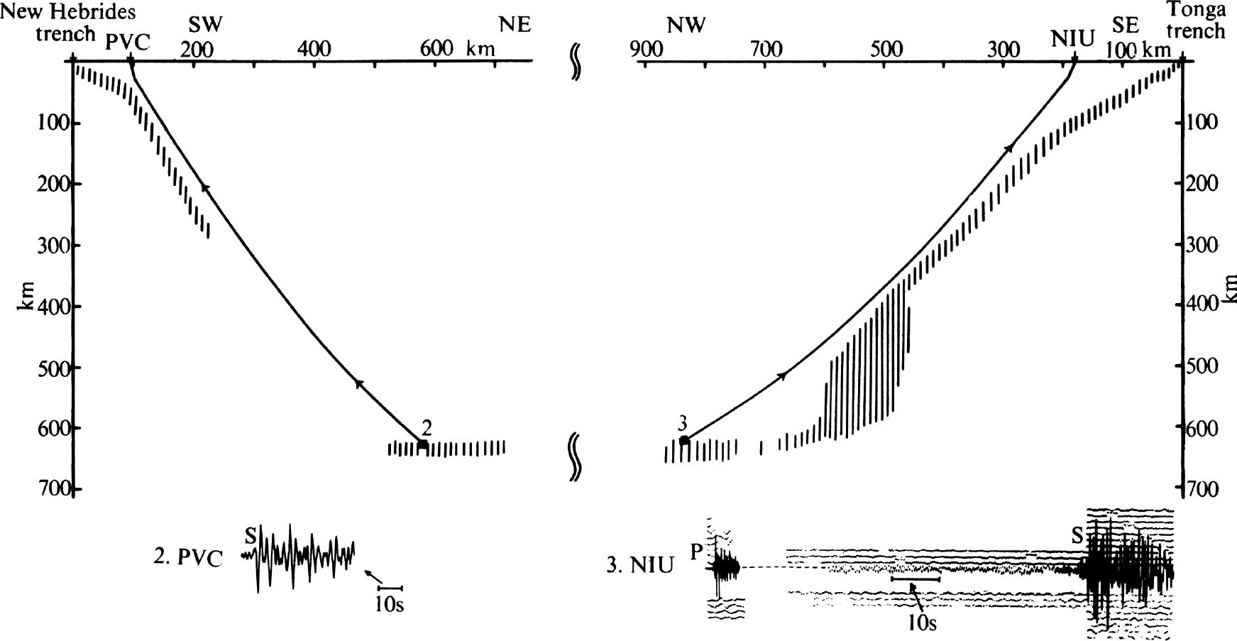
Fig. 3. Two cross-sections of Tonga and New Hebrides arcs showing ray paths to NIU and PVC stations and the corresponding records [E-W component at PVC, and Z component of P, and N-S component of S at NIU] and the locations of seismic activity in the upper mantle (vertical lines). Note the great difference in the signature of S waves at NIU and PVC in spite of the similarity in ray paths (time scale of NIU record is about twice that of PVC).
We will present a detailed study of the travel times of P waves of the New Hebrides deep earthquakes later. The travel time residuals of P waves of the New Hebrides deep earthquakes at PVC and LNR stations along the arc are close to normal (about 1 to 2 s earlier). This is in contrast to P residuals of about 4 to 5 s earlier from the Tongan deep earthquakes recorded at stations along the Tonga arc 8 . Thus the travel time data support those obtained from seismic wave attenuation and indicate that the deep earthquakes at the northeast of the arc represent a detached lithospheric slab. 中文
During the past seven years three deep earthquakes occurred south of 15° S, south of the horizontal oblong-shaped zone, and are located along a line parallel to the southern part of the New Hebrides arc (Fig. 5). Records produced by these earthquakes at NOU in New Caledonia and at stations located in the northern part of the New Hebrides arc (to the north of about 16° S latitude, LNR and LUG) show attenuated, low frequency S waves. But records produced at PVC from the most recent event located at about 18° S and 173° E show large amplitude, high frequency S waves. This is the only one of the three shocks recorded at PVC with good quality records. This observation is quite clear, however, and may imply the continuity of the descending slab in the southern part of the New Hebrides arc. More data are required before a meaningful interpretation can be made for the southern deep earthquakes zone. 中文
In New Zealand earthquakes reach a depth of about 300 km in the North Island and about 200 km in the northernmost part of the South Island. In addition three earthquakes occurred at depths of about 600 km in 1953 and 1960 beneath the North Island 9 . Fig. 4 shows a cross-section of the New Zealand arc and examples of seismograms from the local New Zealand network. Deep earthquakes produce high frequency S waves at Wellington (WEL). Two quite different explanations can be made for this. One is that the slab beneath New Zealand is continuous and reaches depths of at least 600 km, and thereby provides a path for high frequency S waves. The second is that although the slab may have a gap beneath about 300 km, the portion above 300 km is sufficient to provide a “window” through the zone of high attenuation. This second explanation implies that the principal zone of attenuation is located above 300 km, and thus implies a significant difference between the New Zealand and New Hebrides regions with respect to attenuation below 300 km. 中文

Fig. 4. Cross-section of the New Zealand arc showing ray paths to WEL, TNZ and ONE stations, horizontal records to WEL, ONE and GPZ stations, and the dipping seismic zone beneath the North Island (vertical lines). Insert map shows the locations of stations (●) and the location of the deep earthquakes of New Zealand (■).
The second alternative, that a detached lithosphere is present beneath the North Island of New Zealand, is supported by the variation of down-dip length of the inclined seismic zone as a function of latitude along the New Zealand—Kermadec—Tonga plate boundary. If New Zealand deep earthquakes are excluded, the down-dip length increases regularly northward as predicted by locations of the pole of relative motion between the Australian and Pacific plates 10,11 . The New Zealand deep shocks are thus distinctly anomalous in this respect and seem to mark a detached piece of plate. 中文
New Zealand deep earthquakes produce low frequency, attenuated S waves at Tarata (TNZ) and Onerahi (ONE) which are located to the west of the line of active volcanoes in the North Island. Mooney 12 mapped a zone of anomalously high attenuation in the uppermost mantle also located west of the active volcanoes. Thus, the low frequency S waves at TNZ and ONE are probably the result of attenuation in the uppermost mantle to the west of the dipping seismic zone. 中文
An interesting observation is that New Zealand deep shocks produce high frequency S waves at stations in the South Island. Fig. 4 shows an example recorded at Gebbies Pass (GPZ), a station located along the aseismic 13 east coast of the South Island. This observation suggests that beneath at least the northern part of the South Island no major zone of attenuation is present. The lithosphere marked by intermediate depth earthquakes beneath the North Island may thus extend beneath part of the South Island. 中文
An unusual feature of the earthquake distribution in the Tonga-Fiji region is the occurrence of deep earthquakes west of the inclined seismic zone of the Tonga arc (Fig. 5). In the past 10 yr about 8 well located deep earthquakes occurred beneath the Fiji Islands. It is not clear whether these earthquakes represent a continuation of the descending Tonga slab, a slab(s) detached from the present descending slab, or a slab detached during an earlier episode of underthrusting. Evidence obtained from focal mechanisms by Isacks et al . 14 suggests that these earthquakes represent a contorted continuation of the northern edge of the descending Tonga slab. In any case these earthquakes and the New Hebrides deep earthquakes show a considerable horizontal extent away from the corresponding descending slabs. This suggests that the earthquakes mark lithospheric slabs that are unable to penetrate the 600-700 km discontinuity of the upper mantle, and hence the discontinuity may represent the lower limit of the asthenosphere. These slabs may pile up above the discontinuity until their assimilation in the mesospheric lower mantle. 中文
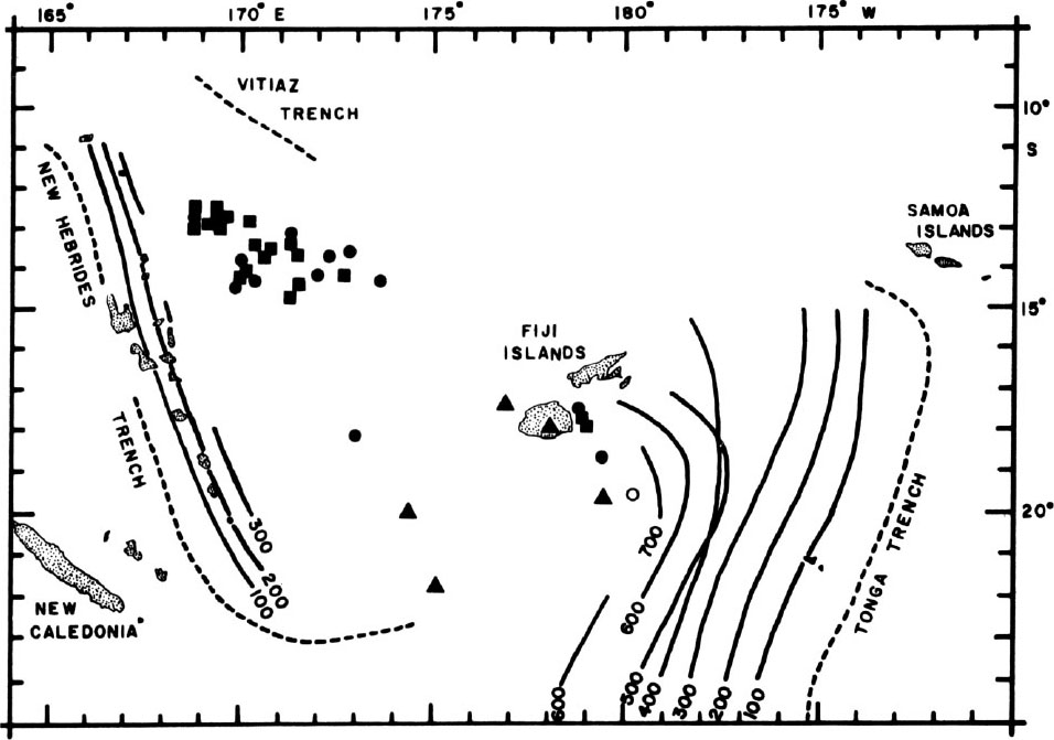
Fig. 5. Map showing contours of earthquake depths for Tonga and New Hebrides arcs, the deep seismic zone of New Hebrides, and well located deep earthquakes beneath the Fiji islands and the Fiji plateau. ▲, Events with depth range between 525 and 575 km; ●, events with 576 to 625 km depth; ■, events with 626 to 675 km depth. The open circle represents an event with a depth of 470 km.
The New Hebrides and New Zealand deep earthquakes mark detached pieces of lithosphere in the upper mantle; considerable seismic wave attenuation probably exists below about 300 km of depth in the upper mantle beneath the northern part of the New Hebrides arc, which implies that the asthenosphere may extend deeper than 300 km in the mantle in this region; the spatial distribution of deep earthquakes between the New Hebrides and Tonga arcs suggests that slabs of lithosphere are unable to descend beneath about 700 km in the mantle. 中文
We thank R. D. Adams for original seismograms, Walter Mitronovas for discussions, and Jim Gill and Dan Karig for preprints of their research. M. B. thanks Maurice Ewing for a research grant. 中文
This work was supported by National Science Foundation grants. 中文
( 242 , 98-101; 1973)
Muawia Barazangi * , Bryan L. Isacks * , Jack Oliver * , Jacques Dubois † and Georges Pascal †
* Department of Geological Sciences, Cornell University, Ithaca, New York 14850
† Office de la Recherche Scientifique et Technique, Outre-Mer, Noumea, New Caledonia, and Institut de Physique du Globe, Université de Paris, 6 Paris
Received October 24, 1972.
References: